
GPS Camera 55. Field Survey
by Kalimex-Consulting s.r.o. @Blocoware & Stanislav Dvoychenko
iPhone · iPad
Quick verdict
- What it is
- Store information collected; independent summary not yet available.
- At a glance
-
- Free to download
- In-app purchases
Categories and search queries
Official categories
- Navigation
- Photo & Video
AppCorpus categories
Key functions
| Function | Availability | Access | Scope | Evidence |
|---|---|---|---|---|
| Family Sharing | Yes | Unknown | App Store | Store published |
| Free app | Yes | Free | — | Store published |
| In-app purchases | Yes | Limited free | — | Store published |
Screens
App Store
31 store screenshots


Pricing & paywalls
App Store
- Pro pack. — $1.99
- Pro pack. — $9.99
- Pro pack. — $24.99
Ratings & reviews
App Store
-
5/5There’s other options but this one is the best!!
I am a very particular person when it comes to using applications like this. This tool is an excellent resource for work-related tasks. I perform numerous QA/QC inspections, and I need a solution that can prove I took a photo, capturing the location and timestamp. Fortunately, this app handles all of that automatically. I can export detailed PDF reports, generate CSV files for data analysis, and automatically upload everything to iCloud for easy access. However, I wish it integrated with OneDrive, as that would be a valuable addition. Other than that, the only missing feature is team collaboration options. Despite this, it remains a fantastic app. I highly recommend it. I’ve tried several other similar apps, which offer various features, but none match the comprehensive functionality of this one.
Seabass8722 · 6 Aug 2026
-
5/5Photo documentation DONE RIGHT
-Photographic records of work performed with no room for questions by anyone. -Customer support without delay. -Functionality to suit your needs. -Clean layout. I could go on and on, I’ve been actively using this app for about three years now. Exporting and sharing options to suit any need I could imagine (jpg, kml, pdf, and others that are more complicated). I do keep my usage pretty straight forward. But the finished result of using this app is a photographic history of what is, what was, and what there will be (left to deal with by other people). After showing others the clear, concise, repeatable information (a picture is worth a thousand words) captured by this app, I have heard thousands of words of praise. A must have app, IMHO. I regret being limited to only 5 stars. Stop reading reviews and download it, try it out for yourself.
Neo2TTH! · 6 Aug 2026
-
5/5I thought this app was the best, but it keeps getting better.
This app just keeps getting better and the thing that makes me give it five stars more than anything is that when you email the developer, Stan, he is sure to respond promptly either with solutions or genuine interest to suggestions. I see improvements made all the time to it, like swiping to access the next photo. A huge improvement, though not entirely necessary it just streamlines operating it. Maybe a cloud version where once you upload a set of photos to a point collection, you could then open up that same point collocation on another device and you’d already have the photos there. Still not entirely necessary, but it’d be cool of it worked that way. In any case, well done with the app, Stan. I use this app for inspecting construction sites. The thing is, I use a drone most often to take pictures, all of which will have the geodata and the time in it's EXIF and when I would take the images and render them through the app, it would watermark the coordinates of where...and the exact time when...the photo was captured by the drone. And, to add, I can add comments to each photo which are watermarked as well. Recently, I suppose due to an update, it watermarks/stamps the time I export the photo instead of the actual time it was taken. Am I doing something wrong all of a sudden or is there a setting to put this back the way it was? Other than that, it's a rare and exceptional app for what I do. So three stars unless I can get it back the way it was. Then 5 for sure. More like 10. Thanks for getting back with me. I took what you said and it worked pretty good. Still seems like it could confuse others and it would be nice to have the ability to change the date/time format. Otherwise it works the way I need, so thanks again for responding with the solution. I will increase one star. It is a terrific tool.
i ❤️Cows · 6 Aug 2026
-
5/5Highly modifiable; responsive development team
The app is incredibly modular in the approach to include information of the photo stamps. This allows for easy alterations for different use cases. Admittedly, there is a bit of a learning curve for users to utilize all of the features, but the effort is worth it. Additionally, the customer service and development teams respond swiftly to inquiries, with complete answers rather than re-hashing tutorial-like information. Their support makes it feel like they are people that care about the app, rather than cash-grabs of some other apps. I whole-heartedly recommend this app, as of August 2024 (I’ve used it for 3 months thus far).
BoggySwamp · 6 Aug 2026
-
5/5Love it for Work!
I do a lot of traveling and take tons of photos. Sometimes I visit multiple sites per trip and many of the projects are similar. With the GPS location on the photos I can immediately determine what photos go with which project. The compass functions also allow me to know which direction I was facing with when taking the photo which can really help. Many people have wanted me to join CompanyCam but I refuse because I find this app much more useful. It also saves me money! I strongly recommend this app.
Ejsrun · 6 Aug 2026
Privacy & accessibility
App Store
Privacy
- Data Not Collected Developer declared
Accessibility
No accessibility labels collected yet.
Versions
App Store
-
3.5
◆ You can now order point collections manually and newest collections are shown on top by default. MENU > POINT COLLECTIONS > Edit. ◆ You can now sort point collections by name or date of creation. MENU > POINT COLLECTIONS > Bottom-right sort button.
-
3.5.1
Quick fix: Making sure that heic and live photo metadata (exif, iptc, tiff) are properly imported for a single and multiple photo import from the photo library. Some changes between iOS 15 versions needed an extra handling for heic and live photo metadata import. Version 3.5: ◆ You can now order point collections manually and newest collections are shown on top by default. MENU > POINT COLLECTIONS > Edit. ◆ You can now sort point collections by name or date of creation. MENU > POINT COLLECTIONS > Bottom-right sort button.
-
3.6
◆ Optimized for iOS 16.: • Paste buttons are changed to the new iOS 16 paste buttons that don't ask for a permission every time you need to paste. • Compiled and tested under iOS 16 SDK. ◆ Added history for the note fields. Should save some typing! ◆ Added a settings button to the Notes Editor screen to open the notes editor settings with one tap. ◆ Added history settings to the notes editor settings screen. ◆ Added options for the app icon. 3 app icons are available in this release. ◆ Fixed the bug with the default points collection not being changed on the main screen when collection was selected as a default on the collection list screen.
-
3.7
◆ Optimized for iOS 16.4. ◆ You can now re-apply comments from existing points/photos to fill all manual comment fields for the new photo, at once. Should give a productivity boost for re-inspections. It's a new bottom section in the comments editor screen. ◆ Removed full swipe delete gesture in the list of photos as it was causing unwanted deletes. Thank you for the feedback! You can still delete by swipe, but need to swipe and then tap on the delete button. ◆ Apple Watch companion app reworked and now only supports WatchOS 7 and higher (so even Watch Series 3 still stays supported). If you don't notice this re-write, it's a success :). ◆ Bug fixes and optimizations: ‣ Fixed the issue when audio notes for the waypoint would not be recorded on iOS 16.2 and iOS 16.3. Thanks to Wolfgang for reporting the issue. ‣ Fixed the rare issue when the app might take the photo on start unintentionally on iOS 16 (related to volume up/down changes in iOS 16). Thanks to Owen for reporting the issue. ‣ Fixed malformed file name for the jpg file to share from the Image Preview when image title is empty. Thanks to Paul for reporting the issue. Thank you for the ongoing feedback and trust!
-
3.8
◆ Center cross size can be now customized. Settings > Other overlays. ◆ Watermark size can be now customized. Settings > Watermark. ◆ All of the app settings (excluding access protection) can be now saved or shared. Allows you to pick the right settings profile for the specific work or quickly onboard a new team member. Settings > Share your settings. ◆ Scanner section is added to the photo notes editor. Scanner allows to extract lines of text from QR, barcode or texts and assign them to the note fields. ◆ Added documentation pages for sharing the app settings and using scanner.
-
3.9
◆ Now you can configure the automatic photo title that goes far beyond the timestamp. Combine collection name, timestamp, custom text and auto increment number in any way that suits best your work or project. Timestamp still stays as a default automatic photo title. ◆ When viewing saved photos, the app now remembers if your last view choice was the original photo or stamped. No need to switch to the stamped view everytime, your preference is now remembered. - If this breaks your current workflow anyhow, you can configure different viewing preferences. Settings > Viewing saved photos. ◆ When you open photo from the points list, the app now provides controls to navigate through the adjacent photos in the points list, without the need to return to the list. You can swipe through or use left/right arrows. ◆ Points list now shows a footer with help and description for the applied filter and sort order, so there is no confusion for what and why is shown in the list.
-
3.9.1
◆ Optimized for iOS 17. ◆ Removed support for iOS 12-14. Supported iOS versions are now 15, 16, 17. You can still install older app versions on the devices with older iOS versions.
-
3.9.2
A smaller release on a path to a bigger one. New options for PDF reports: • Content layout of 2x photo or 2x photo and text per PDF page. • Option for US Letter PDF page size. A4 stays the default option.
-
4.0
◆ Customizable, pattern based file names for saving, sharing and exporting photos. Settings > Photo file name pattern: • Allows to set a file name pattern for a single file. • Batch file name pattern can be based on a single file name pattern or can be independent. • Supported pattern fields are photo title, note, address, folder/tags field name, folder/collection, coordinates, altitude, heading, capture date. • You can define date/time format for the capture date pattern field, number of leading zeroes in the batch file sequence number, whitespace handling. * If you decide to keep the default - photo title is used as a photo file name, as always. ◆ Following turn by turn navigation link options added to a QR-code stamp: Waze, Yandex.Navi, Yandex.Maps, Guru Maps. Settings > QR-code Stamp. ◆ Guru Maps added as a turn by turn navigation option for a navigation to a point.
-
4.1
You can now change the color of buttons in the app. This should provide more options for improved visibility of buttons in bright sunlight and potentially assist in cases involving color vision deficiencies. Settings > Button colors.
-
4.2
◆ Added a new text input-based coordinates converter. You'll find it in several places: - MENU > Coordinates converter. - In the point editor, to the left of the Done button or in the Latitude/Longitude, UTM, MGRS rows. - On the map, in the map search > Coordinates. • The new coordinates converter also supports the OSGB and SK 42 coordinate systems, in addition to the current Latitude/Longitude, UTM, and MGRS formats. • This is part of our ongoing effort to bring support for the majority of EPSG coordinate systems to the app. We hope the new coordinates converter proves to be a useful tool. • Please let us know via a review or at [email protected] if you'd like to see your preferred coordinate system added.
-
4.3
◆ Optimizations for iOS 18. Supported versions of iOS are now 15-18.
-
4.3.1
◆ More updates for iOS 18: • The search text for points, places, and addresses is now properly displayed in black on iOS 18 devices. • Fixed an issue where the new coordinates converter was not displayed in the point editor. This issue was not related to iOS 18 but was caused by the new development tools, affecting all devices from iOS 15 to 18.
-
4.4
◆ Siri/Shortcuts Integration: • Launch the camera with note fields set via Siri or Shortcuts automation. • Simple command templates to open the camera with a title or note. • Advanced command template to open the camera with any or all note fields. • Leverage all Shortcuts app parameters, such as Clipboard, inputs from other apps, etc.
-
4.4.1
◆ Updated the World Magnetic Model for 2025–2029 to ensure accurate declination data between true north and magnetic north. Even if it’s hidden from view in the app, the World Magnetic Model (WMM) is used whenever you import photos or points that define only a true or magnetic direction. The missing counterpart (true or magnetic) is then calculated based on the WMM. Credit for the model goes to the United States’ National Geospatial-Intelligence Agency (NGA) and the United Kingdom’s Defence Geographic Centre (DGC). NCEI and the British Geological Survey (BGS) jointly developed the WMM.
-
4.5
+ Crop, Resize, Tilt, and Rotate tool added. Its button is located to the right of the Stamp button in the image preview toolbar. + Overlay size for both location and notes can now be customized: small (current and default), medium (25% larger), or big (50% larger). You’ll find this in Settings > 'Location overlay' and 'Notes overlay'. + You can now restore app settings directly within the app. Settings > 'Settings: Backup, share, restore.' now includes a 'Restore' button, allowing you to open and apply previously saved settings without leaving the app. + Points and photos can now be imported from files directly within the app. Supported formats: KMZ, KML, GPX, CSV, and TXT. Use the ‘More’ button on the Points screen. + Default sort by date for points has also been moved to the ‘More’ button.
-
4.6
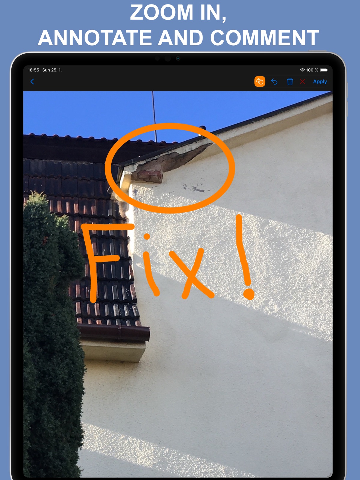
◆ New drawing tools for annotating photos: + Arrow, Rectangle, Circle, Cross pointer. + You can also adjust the line width. • We hope these additions give you even more control and precision in your annotations!
-
4.7
◆ Batch Export of Collections: Export multiple point/photo collections at once as a single KMZ file. ◆ Batch Enable/Disable Collections: Easily enable or disable several point/photo collections in one go. → To use: tap the new 'more' button (left of the '+' in the collections list), choose Select, pick collections, then choose an action from the bottom toolbar. ◉ The ability to enable or disable multiple collections at once helps you focus only on the points/photos relevant to your project. Multi-collection KMZ export is fully compatible with the Google Earth desktop app and can be used to back up all your collections and points if needed. 100% of the data is preserved when importing back into the app on another device. ◆ Enhanced KMZ Import: Now supports KMZ archives with multiple subfolders and multiple KML files. → Import via the 'more' button on the points/photos list or the 'Open In' system option on iPhone/iPad.
-
4.8
■ Updates and optimizations for iOS 26 and beyond: • Significantly faster camera startup. • Reworked toolbars for image annotation, collections list, and points list — ensuring a consistent user experience from iOS 15 through iOS 26. • Optimized photo stamping for higher speed and improved compatibility with iOS 15 and older devices (e.g., iPhone 6S). • Fixed an issue on older devices where the camera might not appear when opened from the Point Editor.
-
4.8.1
• Fixed search button not being shown in some cases in points list.
-
4.9
• Added clickable map links to PDF reports and emails! You and your clients can now navigate to photo locations or view them in Apple Maps or Google Maps with a single tap. Configure in Settings > PDF & Email. • Fixed an issue where bottom toolbar buttons were difficult to see on iOS 26.1. • Fixed an issue where exporting multiple collections failed on smaller devices like iPhone 12 mini running iOS 26.
-
5.0
■ Trash for Deleted Photos & Points Accidentally deleted a photo? Now you can get it back. On your first delete, you'll be asked whether to enable Trash protection—or configure it anytime in Settings > Deletion & Trash Management. With Trash enabled, deleted items stay recoverable for 30 days before permanent removal. Access Trash from the collections filter in your points/photos list (MENU > POINTS) or in the settings. ■ Redesigned Watch App Completely rebuilt watch companion app using Apple's latest technology for better performance and reliability. ■ Improved KML/KMZ Export Exported files now preserve original creation dates and last-modified timestamps, so re-importing your data keeps all date information intact. ■ Reworked Numeric Keyboard Dedicated numeric input keyboard (used for UTM, MGRS coordinates, etc.) now works properly and looks modern across all iOS versions 15-26. Fixed iPadOS 26 showing its own floating numeric pad alongside ours, and iOS 26 keyboard dismiss button losing proper placement after screen rotation.
-
5.0.1
• Fixed alignment of landscape photo preview on iOS 26.3 and iPadOS 26.3. The top part could be hidden behind the navigation bar and required scrolling — now fixed. • Fixed photo capture screen not setting landscape orientation properly after a fresh app start on the latest iOS 15 version. • Improved iPadOS 16–26 multitasking compatibility for the camera (Split View / Stage Manager). ◆ Don’t miss the major changes from the previous version: ■ Trash for Deleted Photos & Points Accidentally deleted a photo? Now you can get it back. On your first delete, you'll be asked whether to enable Trash protection—or configure it anytime in Settings > Deletion & Trash Management. With Trash enabled, deleted items stay recoverable for 30 days before permanent removal. Access Trash from the collections filter in your points/photos list (MENU > Points) or in the settings.
-
5.1
■ Draw More Freely ‣ Add double-headed arrows, dimension lines, and text labels to call out details more clearly. ‣ You’re no longer limited to 8 fixed colors. Choose your own stroke and fill colors to match your style and needs. ‣ Adjust stroke and fill transparency separately for clearer overlays. ■ Edit Drawings Later ‣ Starting with version 5.1, drawings are saved in photo metadata instead of being baked into the saved photo, so you can select, edit, or delete them later. ‣ Use the new arrow button in the paint toolbar to enter selection mode. ‣ Tap a drawing’s border to select it, then use the Style button to change stroke, fill, transparency, or colors. ‣ Use the Text button to attach text to a drawing or edit the attached text. ‣ The trash button in the paint toolbar now removes all drawings, letting you return to the photo without drawings. If the photo was cropped or resized, the result is the cropped or resized photo, not the original uncropped image. ■ Share and Restore More Reliably ‣ Photos can still be shared with drawings applied, with or without location and note stamps, just like before. ‣ KMZ export still supports the previous presentation-style option that exports photos with drawings applied. ‣ A new KMZ export option now includes both the rendered photo and the original image with drawing metadata, so imports can restore your drawings for later editing. ‣ Please note: this rework only applies to drawings created in version 5.1 and later. ■ Quality of Life Improvements ‣ The automatically resolved address shown in the camera viewfinder now displays a warning indicator when the address is stale or when address resolution failed. ‣ Fixed the HTML formatting warning shown in Google Earth for Mac and PC when opening exported photo popups. Loving the app? Your rating makes a huge difference. Please take a moment to leave one — it means the world to us!
-
5.1.1
· 9 May 2026
■ Improved toolbars for compact screens on iOS 26 ‣ Paint and selection tools now stay within easy reach on very narrow iPhone layouts and small iPad app windows. They move to the bottom toolbar instead of being tucked away in an overflow menu, making drawing, selecting, and applying changes faster on iOS 26 and iPadOS 26. ‣ Camera and preview actions now also have clear names when iOS 26 places them in the overflow menu, so Save, Notes, Drawing tools, Crop, Flash, Settings, and camera switching remain easy to find. ‣ Huge thanks to Ed for reporting the compact-screen toolbar issue and sharing screenshots. Don't miss the major version updates: ■ Draw More Freely ‣ Add double-headed arrows, dimension lines, and text labels to call out details more clearly. ‣ You’re no longer limited to 8 fixed colors. Choose your own stroke and fill colors to match your style and needs. ‣ Adjust stroke and fill transparency separately for clearer overlays. ■ Edit Drawings Later ‣ Starting with version 5.1, drawings are saved in photo metadata instead of being baked into the saved photo, so you can select, edit, or delete them later. ‣ Use the new arrow button in the paint toolbar to enter selection mode. ‣ Tap a drawing’s border to select it, then use the Style button to change stroke, fill, transparency, or colors. ‣ Use the Text button to attach text to a drawing or edit the attached text. ‣ The trash button in the paint toolbar now removes all drawings, letting you return to the photo without drawings. If the photo was cropped or resized, the result is the cropped or resized photo, not the original uncropped image. ■ Share and Restore More Reliably ‣ Photos can still be shared with drawings applied, with or without location and note stamps, just like before. ‣ KMZ export still supports the previous presentation-style option that exports photos with drawings applied. ‣ A new KMZ export option now includes both the rendered photo and the original image with drawing metadata, so imports can restore your drawings for later editing. ‣ Please note: this rework only applies to drawings created in version 5.1 and later. ■ Quality of Life Improvements ‣ The automatically resolved address shown in the camera viewfinder now displays a warning indicator when the address is stale or when address resolution failed. ‣ Fixed the HTML formatting warning shown in Google Earth for Mac and PC when opening exported photo popups. Loving the app? Your rating makes a huge difference. Please take a moment to leave one — it means the world to us!
Alternatives
- My GPS Coordinates ° — Same category + similar ratings
- Coordinates – GPS Converter — Same category + similar ratings
- GPS Maps Camera — Same category + similar ratings
- Geo Timestamp : GPS Map Camera — Same category + similar ratings
- GPS Tracker: Offline Maps, GPX — Same category + similar ratings
- Guru Maps - Offline Navigation — Same category + similar ratings
Availability by market
- US
Data quality & evidence
- Page completeness
- Live store listing
- Last verified
- 6 Aug 2026
- Sources
- App Store
- Independent summary has not been published yet.