
Quick verdict
- What it is
- Store information collected; independent summary not yet available.
- At a glance
-
- From $3.99/mo
- Free to download
- In-app purchases
Categories and search queries
Official categories
- Maps & Navigation
- Navigation
- Health & Fitness
AppCorpus categories
Key functions
| Function | Availability | Access | Scope | Evidence |
|---|---|---|---|---|
| Family Sharing | Yes | Unknown | App Store | Store published |
| Free app | Yes | Free | — | Store published |
| In-app purchases | Yes | Limited free | — | Store published |
Screens
34 store screenshots

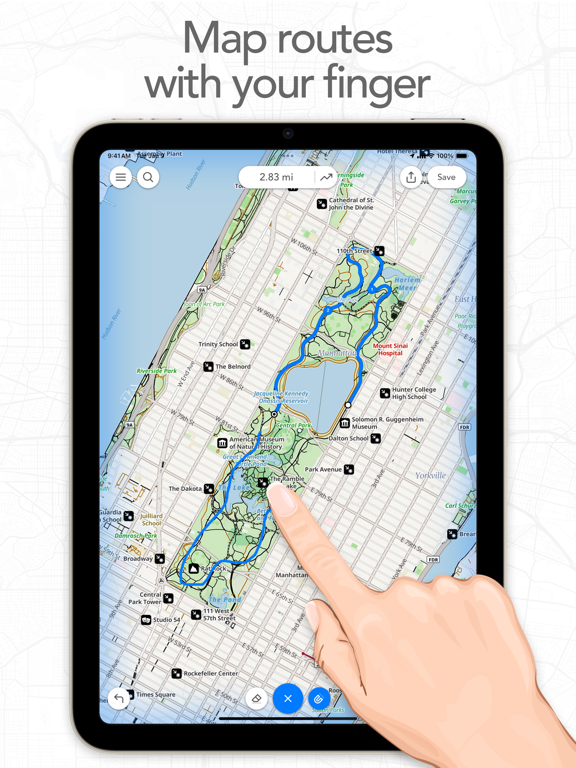

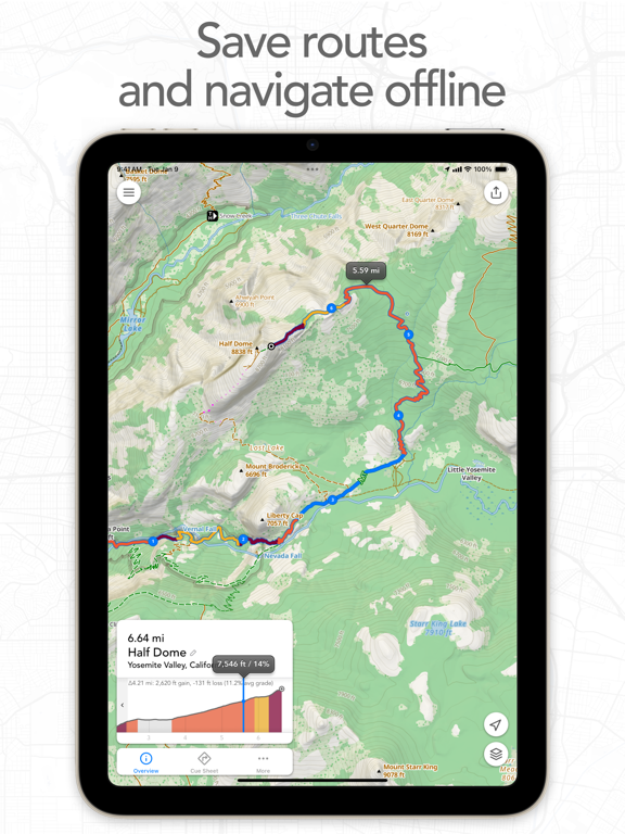
7 store screenshots


Pricing & paywalls
Shown for US
- Footpath Elite (Monthly) — $3.99/month
- Footpath Elite (Monthly) — $23.49/year ($1.95/mo)
- Single Route Pass — $1.99
Shown for US
- Free to download
- In-app purchases: $1.99 - $23.49 per item
Ratings & reviews
Shown for US
-
5/5Fantastic GPX route planning app
This app is absolutely fantastic for planning hikes. Even though we have used other online route apps, we've been looking for an easy to use route planning app for our phones that exports GPX route files for use with our favorite iPhone GPS software (GaiaGPS). Footpath does it seamlessly. We also upload the route files to fitness apps like RunKeeper where it tells us in advance how many calories our planned hikes will burn. Wonderful! Suggested future updates: add the ability to import existing GPX route/track files for easy sharing and editing (this is Footpath's most glaring deficiency in our opinion--right now you can only export routes to other apps); make it possible to easily move starting and mid-points of a route you want to edit (right now you can only edit an existing route by deleting segments of the route starting at the end until you get to a fork or turn you want to explore and then continuing along a new path from there); and it would also be great if your routes were automatically saved to a personal account on a website maintained by Footpath so they could be more easily managed and exported to your favorite GPS and fitness apps. All that said, Footpath is pretty awesome as is and has already benefited us greatly by giving us the ability to quickly and easily plan and execute our weekly hikes anywhere we are whenever we have a couple minutes. Thank you!
comabereni · 30 Aug 2026
-
5/5Tried them all and this is the one for my bike touring/camping
I have paid for and used about all of them for creating a route and adjusting on the fly but, this is the one. Only this app, not OSM, not Naviki, no Guru Mape, not Here, not Garmin, not Google, not Apple… and probably some others I am forgetting do what this app can do and is what I went through all the other apps looking for. At least in the USA only this app easily allows you to connect dedicated bike paths by simply clicking on the OpenCycleMap where you want to go. When you have to venture away from your planned route its interface makes that effortless. Draw with your finger and it will snap to the road and favor bike friendly. If the app snaps to something that you don’t want, click on the eraser until and draw that segment against. So on the side of the road or trail you can create a new plan in less than a minute. Here is the second best thing. It has unrivaled import and export features. More formats and more options to share.
Chief_lee_visceral · 30 Aug 2026
-
3/5Disappointing
First and foremost, this review is strictly for my use case: I wanted a GPS voice navigation app that would run in the background on my Apple Watch while I use the Stryd app to track my running. Footpath is designed to allow this when setting it to "use with other workout app." However, after testing it out what I've learned is that the two apps don't play well together. First I upload or create my route in Footpath, then I go out for my run. Footpath is supposed to stay in the background, give voice turn by turn directions, and send notifications to my Apple Watch. The voice directions work fairly well, prompting me where to make turns. However, the notifications throw everything off. When the notification is dismissed, it often switches to the Footpath app from the Stryd app. When that happens, Stryd loses access to the GPS data it needs and all of my run data gets screwed up. In short, this app is exactly what I need on paper. In reality, it doesn't work as designed (at least with my configuration). After testing a bit further, I think the two will work together if I turn off notifications on my Watch display from Footpath and just listen to the voice alerts. That's better than nothing and still helpful. If I get lost, I can pause my Stryd app workout and switch to Footpath to look at the map. Better than nothing, but hopefully I'm able to find a better solution. Maybe Footpath can work out the kinks, but I'm guessing I'm a niche audience. One last note: take the voice navigation with a grain of salt. Sometimes it misses turns, telling you to continue straight on a road when you’re actually supposed to be turning.
ChrisG1029 · 30 Aug 2026
-
3/5Could be good, but not for my needs
I feel bad rating this too low because I did not use it for very long. However, that is because I started to get genuinely upset with it. It seems that it would be great for legitimate trails, city streets, etc. However, I had great difficulty getting it to stick to actual suburb roads. At one point it decided I should take a nice detour and bike through the pond. When drawing a simple path with a stylus, it thought it would be fun to throw in a few circles. Additionally, it did not give me sufficient editing abilities. On one trip I tried to map, it had a random straight line going through a woods. I attempted to erase it so I could shift it over, but it just kept reappearing in a different, equally incorrect location. It also completely ignores a popular footpath. The “snap to map” is somewhat a useful, and certainly an innovative feature. It just needs some love. I could see this working on longer trips that need less accuracy, but for my suburban 10 mile excursions it brought nothing but anger. For now, I’m going to stick to drawing vauge lines on a map, and finding out the mileage later. TLDR: I can see it’s applications and situations it could be good in. It just is not at all conducive to my biking or running excursions.
HelenB4 · 30 Aug 2026
-
2/5Offline failure in remote wilderness
I have (by time of posting HAD) a paid footpath membership with route downloaded for offline use in remote wilderness. Did some one day testing and all seemed fine. Not great at doing turn by turn in areas with lots of trees and steep topographic terrain, bit this is likely limitation of receiver on device - iphone 13 pro) . Not a deal breaker. What was a deal breaker was on day two of multiday wilderness trip, with iOS and app having been update just prior to trip, app continually failed to open while I was several hours away from fast internet. Tried restarting phone, to no avail. I had to switch to backup map and compass for navigation along with offline Google maps for some topo info. Footpath only began working again when I could connect to faster itnernet and update app. That's unacceptable for a paid navigation app touting offline capabilities. It cannot fail like that. For me, I want an app that allows hands free turn by turn navigation telling me where to go right, left, or straight, with indications for markers I leave for potable or non potable water all of which I can just listen (with say one earbud inserted) through hands-free 95% of the time without looking at or holding the device. This is not that.
heijamie · 30 Aug 2026
Shown for US
-
5/5
great app, easy to use and very handy
Will .Pendered · 28 Aug 2026
-
5/5
Aplicación práctica y excelente
Brayan Castillo · 28 Aug 2026
-
5/5
great app. Easy to use and makes planning my morning walk a breeze. kinda fun too! you can play with different routes.
Kendrick Taylor · 28 Aug 2026
-
1/5
rubbish
Leigh Grealis · 28 Aug 2026
-
3/5
average.
Epau 974 · 28 Aug 2026
Privacy & accessibility
Privacy
- Data Linked to You — Analytics — Purchases — Purchase History Developer declared
- Data Linked to You — App Functionality — Contact Info — Email Address Developer declared
- Data Linked to You — App Functionality — Contact Info — Name Developer declared
- Data Linked to You — App Functionality — Health & Fitness — Fitness Developer declared
- Data Linked to You — App Functionality — Identifiers — User ID Developer declared
- Data Linked to You — App Functionality — Location — Precise Location Developer declared
- Data Linked to You — App Functionality — Purchases — Purchase History Developer declared
- Data Linked to You — App Functionality — User Content — Other User Content Developer declared
- Data Linked to You — App Functionality — User Content — Photos or Videos Developer declared
- Data Linked to You — Developer’s Advertising or Marketing — Contact Info — Email Address Developer declared
- Data Linked to You — Developer’s Advertising or Marketing — Contact Info — Name Developer declared
- Data Linked to You — Developer’s Advertising or Marketing — Purchases — Purchase History Developer declared
- Data Linked to You — Contact Info Developer declared
- Data Linked to You — Health & Fitness Developer declared
- Data Linked to You — Identifiers Developer declared
- Data Linked to You — Location Developer declared
- Data Linked to You — Purchases Developer declared
- Data Linked to You — User Content Developer declared
- Data Not Linked to You — Analytics — Diagnostics — Crash Data Developer declared
- Data Not Linked to You — Analytics — Diagnostics — Performance Data Developer declared
- Data Not Linked to You — Analytics — Usage Data — Product Interaction Developer declared
- Data Not Linked to You — App Functionality — Search History Developer declared
- Data Not Linked to You — Diagnostics Developer declared
- Data Not Linked to You — Search History Developer declared
- Data Not Linked to You — Usage Data Developer declared
Accessibility
No accessibility labels collected yet.
Privacy
- Data collected — Analytics — App activity — App interactions Developer declared
- Data collected — Analytics — App info and performance — Crash logs Developer declared
- Data collected — Analytics — App info and performance — Diagnostics Developer declared
- Data collected — App functionality — App activity — Other user-generated content Developer declared
- Data collected — App functionality — Health and fitness — Fitness info Developer declared
- Data collected — App functionality — Location — Approximate location Developer declared
- Data collected — App functionality — Location — Precise location Developer declared
- Data collected — App functionality — Personal info — User IDs Developer declared
- Data collected — App functionality, Developer communications, Account management — Personal info — Email address Developer declared
- Data collected — Developer communications, Account management — Personal info — Name Developer declared
- Security practices — Your data is transferred over a secure connection — Data is encrypted in transit Developer declared
- Security practices — The developer provides a way for you to request that your data be deleted — You can request that data be deleted Developer declared
Accessibility
No accessibility labels collected yet.
Versions
-
4.10
INTERACTIVE POIS (ELITE) When using the Footpath Topo or Satellite Topo maps, just tap on a POI and you'll see information about that place from Wikipedia. You can tap the callout to read the full Wikipedia article right from the app, then add it as a waypoint to your route. RE-DESIGNED TOPO MAPS (ELITE) We've redesigned the Footpath Topo map style specifically for pedestrians and cyclists. We've made trails and unpaved roads, landmarks, and national parks more visible to help in planning routes. We've also added a new public transit overlay that will show subways, light rail, and commuter train lines and stations right on the map. MULTIPLE ROUTES ON APPLE WATCH (ELITE) You can now store multiple routes in the Apple Watch app, so you can have multiple options ready when you're offline in the wilderness. ELEVATION PROFILES (ELITE) Dynamic elevation profiles are now available in the navigator on iOS. When you start a climb, the graph will automatically zoom so you know how far you have left to the summit. CUSTOMIZABLE METRICS Now on iOS: long-press on the GPS tracker screen to customize the metrics to your liking. We've added a ton of new metrics for you to choose from. Other improvements: - We've fixed an issue sending long, complex routes to an Apple Watch - You can now long press on the map settings button to quickly change map styles - Bug fixes Leave us an App Store review if you're enjoying Footpath, or feel free to contact us at [email protected] with any problems or suggestions.
-
4.10.1
INTERACTIVE POIS (ELITE) When using the Footpath Topo or Satellite Topo maps, just tap on a POI and you'll see information about that place from Wikipedia. You can tap the callout to read the full Wikipedia article right from the app, then add it as a waypoint to your route. RE-DESIGNED TOPO MAPS (ELITE) We've redesigned the Footpath Topo map style specifically for pedestrians and cyclists. We've made trails and unpaved roads, landmarks, and national parks more visible to help in planning routes. We've also added a new public transit overlay that will show subways, light rail, and commuter train lines and stations right on the map. MULTIPLE ROUTES ON APPLE WATCH (ELITE) You can now store multiple routes in the Apple Watch app, so you can have multiple options ready when you're offline in the wilderness. ELEVATION PROFILES (ELITE) Dynamic elevation profiles are now available in the navigator on iOS. When you start a climb, the graph will automatically zoom so you know how far you have left to the summit. CUSTOMIZABLE METRICS Now on iOS: long-press on the GPS tracker screen to customize the metrics to your liking. We've added a ton of new metrics for you to choose from. Other improvements: - We've fixed an issue sending long, complex routes to an Apple Watch - You can now long press on the map settings button to quickly change map styles - Bug fixes Leave us an App Store review if you're enjoying Footpath, or feel free to contact us at [email protected] with any problems or suggestions.
-
4.10.2
INTERACTIVE POIS (ELITE) When using the Footpath Topo or Satellite Topo maps, just tap on a POI and you'll see information about that place from Wikipedia. You can tap the callout to read the full Wikipedia article right from the app, then add it as a waypoint to your route. RE-DESIGNED TOPO MAPS (ELITE) We've redesigned the Footpath Topo map style specifically for pedestrians and cyclists. We've made trails and unpaved roads, landmarks, and national parks more visible to help in planning routes. We've also added a new public transit overlay that will show subways, light rail, and commuter train lines and stations right on the map. MULTIPLE ROUTES ON APPLE WATCH (ELITE) You can now store multiple routes in the Apple Watch app, so you can have multiple options ready when you're offline in the wilderness. ELEVATION PROFILES (ELITE) Dynamic elevation profiles are now available in the navigator on iOS. When you start a climb, the graph will automatically zoom so you know how far you have left to the summit. CUSTOMIZABLE METRICS Now on iOS: long-press on the GPS tracker screen to customize the metrics to your liking. We've added a ton of new metrics for you to choose from. Other improvements: - We've fixed an issue sending long, complex routes to an Apple Watch - You can now long press on the map settings button to quickly change map styles - Bug fixes Leave us an App Store review if you're enjoying Footpath, or feel free to contact us at [email protected] with any problems or suggestions.
-
4.10.3
- Support for iOS 18, watchOS 11 - Support for Apple Watch Series 10 - Bug fixes Leave us an App Store review if you're enjoying Footpath, or feel free to contact us at [email protected] with any problems or suggestions.
-
4.10.4
- Fix delay in bookmark syncing - Better handle malformed GPX files when importing routes - Fix waypoint alerts if navigating an unsnapped route - Show degrees slope instead of percent grade for winter and mountaineering activities - Bug fixes Leave us an App Store review if you're enjoying Footpath, or feel free to contact us at [email protected] with any problems or suggestions.
-
4.10.5
- Bug fixes Leave us an App Store review if you're enjoying Footpath, or feel free to contact us at [email protected] with any problems or suggestions.
-
4.10.6
- Bug fixes Leave us an App Store review if you're enjoying Footpath, or feel free to contact us at [email protected] with any problems or suggestions.
-
4.10.7
- Bug fixes Leave us an App Store review if you're enjoying Footpath, or feel free to contact us at [email protected] with any problems or suggestions.
-
4.10.8
- Bug fixes Leave us an App Store review if you're enjoying Footpath, or feel free to contact us at [email protected] with any problems or suggestions.
-
4.10.9
- Bug fixes Leave us an App Store review if you're enjoying Footpath, or feel free to contact us at [email protected] with any problems or suggestions.
-
4.11
· 23 Jul 2026
- Improved map rendering on Apple Watch, added road and trail labels when panning the map - Fixed an issue where subscriptions would fail to refresh if cellular Low Data Mode was enabled - Fixed an issue dragging to reorder routes in a list on iOS 26 - Fixed an issue loading images in Wikipedia articles - Bug fixes Leave us an App Store review if you're enjoying Footpath, or feel free to contact us at [email protected] with any problems or suggestions.
-
4.11.1
- Fixed an issue with elevations in GPX exports - Bug fixes Leave us an App Store review if you're enjoying Footpath, or feel free to contact us at [email protected] with any problems or suggestions.
-
4.11.2
· 5 Aug 2026
- Fixed an issue with elevations in GPX exports - Bug fixes Leave us an App Store review if you're enjoying Footpath, or feel free to contact us at [email protected] with any problems or suggestions.
-
4.9.10
- iOS 17 and watchOS 10 compatibility - Bug fixes Leave us an App Store review if you're enjoying Footpath, or feel free to contact us at [email protected] with any problems or suggestions.
-
4.9.11
- iOS 17 and watchOS 10 compatibility - Bug fixes Leave us an App Store review if you're enjoying Footpath, or feel free to contact us at [email protected] with any problems or suggestions.
-
4.9.12
- Bug fixes Leave us an App Store review if you're enjoying Footpath, or feel free to contact us at [email protected] with any problems or suggestions.
-
4.9.13
- Bug fixes Leave us an App Store review if you're enjoying Footpath, or feel free to contact us at [email protected] with any problems or suggestions.
-
4.9.14
- Fixes an issue where the elevation profile on Apple Watch could show an incorrect location - Bug fixes Leave us an App Store review if you're enjoying Footpath, or feel free to contact us at [email protected] with any problems or suggestions.
-
4.9.15
- Bug fixes Leave us an App Store review if you're enjoying Footpath, or feel free to contact us at [email protected] with any problems or suggestions.
-
4.9.2
- Added an optional setting to rotate the Apple Watch topo maps based on your compass heading - Restores basic "breadcrumb" maps on the Apple Watch Series 3. Unfortunately the Series 3 does not have the memory to support the new topo maps. - Fixes performance issues/crashes when scrolling between metrics screens - Bug fixes Leave us an App Store review if you're enjoying Footpath, or feel free to contact us at [email protected] with any problems or suggestions.
-
4.9.3
- Added an optional setting to rotate the Apple Watch topo maps based on your compass heading - Restores basic "breadcrumb" maps on the Apple Watch Series 3. Unfortunately the Series 3 does not have the memory to support the new topo maps. - Fixes performance issues/crashes when scrolling between metrics screens - Bug fixes Leave us an App Store review if you're enjoying Footpath, or feel free to contact us at [email protected] with any problems or suggestions.
-
4.9.4
- Fixes map context menu on macOS Ventura - Bug fixes Leave us an App Store review if you're enjoying Footpath, or feel free to contact us at [email protected] with any problems or suggestions.
-
4.9.5
- Bug fixes Leave us an App Store review if you're enjoying Footpath, or feel free to contact us at [email protected] with any problems or suggestions.
-
4.9.6
- Fixes issue on Apple Watch Ultra where Action Button would stop displaying maps after a pause - Improvements saving data to Apple Health - Bug fixes Leave us an App Store review if you're enjoying Footpath, or feel free to contact us at [email protected] with any problems or suggestions.
-
4.9.7
- Fixes issue on Apple Watch Ultra where Action Button would stop displaying maps after a pause - Improvements saving data to Apple Health - Bug fixes Leave us an App Store review if you're enjoying Footpath, or feel free to contact us at [email protected] with any problems or suggestions.
-
4.9.8
- Fixes issue saving active calories to Apple Health - Bug fixes Leave us an App Store review if you're enjoying Footpath, or feel free to contact us at [email protected] with any problems or suggestions.
-
4.9.9
- iOS 17 and watchOS 10 compatibility - Bug fixes Leave us an App Store review if you're enjoying Footpath, or feel free to contact us at [email protected] with any problems or suggestions.
- 2.4.0 · 12 Mar 2026
Alternatives
- Gaia GPS: Mobile Trail Maps — Same category + similar ratings
- Avenza Maps: Offline Mapping — Same category + similar ratings
Availability by market
- US
Data quality & evidence
- Page completeness
- Live store listing
- Last verified
- 30 Aug 2026
- Sources
- App Store, Google Play
- Independent summary has not been published yet.